|
<< BACK
|

|
SPACE BASED INFORMATION SUPPORT FOR DECENTRALIZED PLANNING
(Sponsored by ISRO)
Planning Commision suggested in faclitating the implementation of beneficiary oriented
developmental programmes and its subsequent monitoring,impact evaluation, using
high resolution satellite data and their derived thematic layers. Followed by the
decision taken in the 17th meeting of the PC-NNRMS, and to effectively support the
decentralized planning process in the country with revelant satellite remote sensing
based geo-spatial data and services, ISRO has taken up a project on "Space Based
Information Support for Decentralized Planning (SIS-DP)".The programme aims at generating
geo-spatial information catalogue at detailed scale (1:10,000) for use and seamless
integration with the data/information at stakeholders end in district and local
level planning for entire country.ISRO and State Remote sensing centers have jointly
taken up the projects in 5 States including Kerala.Planning & Economic Affairs Department,
Govt. of Kerala has signed a MoU with ISRO designating Kerala State Remote Sensing
& Environment Centre as the State Government nodal agency for implementation of
the "Space Based Information Support for Decentralized Planning" project.
|
|
Spatial Geo-database Creation
|
Spatial depiction of land & water
resource along with their attribute information for preparation of District Resource
Geospatial Atlas keeping Village Cadastral data as base in a virtual on seamless
manner for entire country;
|
|
|
|
Decision making tool & dissemination
|
Development of software tools and
utilities (including standalone and web based GIS applications) for providing multipurpose
user driven applications for speedy, accurate and transparent decision making for
district planning; and
|
|
|
|
Capacity building
|
Capacity building in state departments
along with training of manpower and capability for spatial data analysis, which
will maintain, update & manage database for decentralized planning.
|
|
LAND COVER
|
ROADS
|
SLOPE
|
SOIL & WATER PROSPECT
|
SETTLEMENTS
|
TABULAR DATA
|
Built-up
Mining
Cropland
Horticulture
Aquaculture
Forest
Mangrove
Grassland
Scrubland
Barren rocky
Other wastelands
Snow covered
Water bodies
|
Road Type
- Pucca road
- Kuchha road
Road Status
- National Highway
- State Highway
- District road
- Cart track
- Pack track
- Footpath
|
V.gently sloping
Gently sloping
Mod. sloping
Strong sloping
Mod. steep to steep
V.steep sloping
|
Soil
- Surface texture
- Surface stonliness
- Depth
- Salinity/alkalinity
- Soil drainage
- Erosion,pH,EC
Water Prospect
- Excellent
- Good
- Moderate
- Poor
|
Residential
Mix. Built-up
Recreational
Public utilities
Vegetated areas
Transportation
Industrial
Rural
Mixed rural area
|
Wells,pumps,tanks
Roads,rail
Electricity
Water supply
PDS,Library
Panchayat,Police
Agri. Market
Bank,PO,telegraph
School,college
Dispensary,PHC
Socio-economic
|
|
CURRENT
STATUS
|
LINE FEATURES
|
POINT FEATURES
|
POLYGON FEATURES
|
Cadastral Sheets Procured : 3200 sheets
Cadastral Sheets Scanned : 3200 sheets
Cadastral Sheets Vectorized : 1320 sheets (429 Revenue blocks)
Mosaiced to form blocks : 120 Revenue blocks
Spatially corrected with Image : 49 Revenue blocks
|

|
Road
- Metalled road
- Gravelled road
- Cart track
- Foot path
Rail
Stream
Canal
Powerline
Contour
Flow direction
|
Ammenity
Worship
Bridge
Stone
- Circle
- Square
- Triangle
- Rogue Marsh
Tree
Well
Cemetry
Place
|
Parcel
River
Water body
River Island
Canal
Railway
Mining area
Hilly area
Forest
Plantation
|
|
PLANNING
|
IMPLEMENTATION
|
MONITORING
|
 Optimal
land use planning Optimal
land use planning
Planning
canal,road etc.
Establishment
of markets,health,
education,financing facilities
....................
|
Health,sanitation,employment,housing,
drinking water schemes
Mid-day meal and PDS
Educational,road,irrigation etc.
....................
|
Progress under schemes
Reaching benefits to people
Compensation,Fund allocation and utilization
....................
|
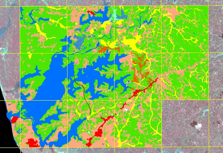
LAND COVER INTERPRETATION FROM LISS IV & CARTOSAT FUSED
DATA
(Chittumala, Sasthakotta, Anchalumoodu, Chavara & Karunagappally block of Kollam
district
|
|
|
|